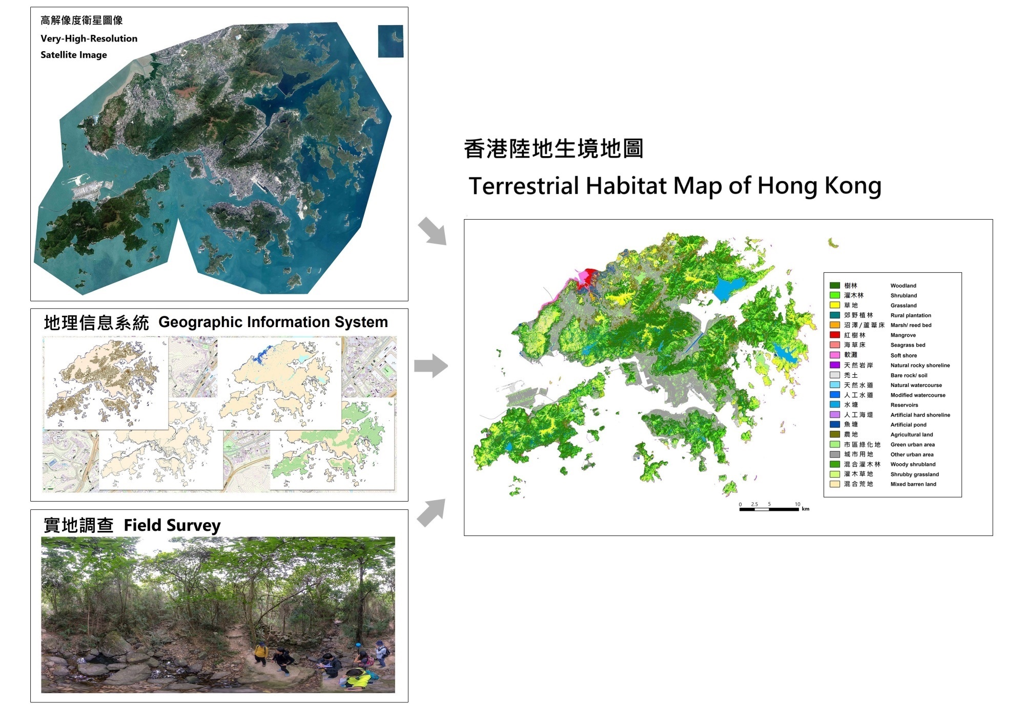
Agriculture, Fisheries and Conservation Department initiated the study titled 'Territory-wide Study on Hong Kong's Terrestrial Habitats Using Remote Sensing and geographic information system (GIS)' and commissioned The Chinese University of Hong Kong (CUHK) to explore the potential of using high-spatial-resolution satellite image to identify and map major terrestrial habitats in Hong Kong.
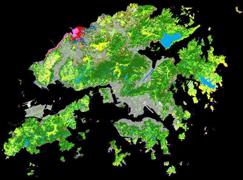
This habitat mapping exercise identified and mapped 21 habitat types in Hong Kong with reference to the Terrestrial Habitat Classification Scheme, including woodland, shrubland, grassland, rural plantation, marsh/reed bed, mangrove, seagrass bed, soft shore, natural rocky shoreline, bare rock/soil, natural watercourse, modified watercourse, reservoirs, artificial hard shoreline, artificial pond, agricultural land, green urban area, other urban area, woody shrubland, shrubby grassland and mixed barren land. A set of very high-resolution satellite images captured by WorldView-2 and -3 satellites in September–December 2019 covering the entire territory in Hong Kong was obtained, processed and mosaicked to serve as one of the main data sources of mapping study.
A three-stage mapping procedure was developed to facilitate effective mapping of each habitat class by combining satellite image classification method and geographical information data. In stage 1, two machine learning-based classification algorithms were tested to classify the satellite image into 11 habitat categories. 15-day field surveys were carried out by qualified field specialists to collect reference data as the input for improving the classification accuracy. In stage 2, the initial classification results were modified using a set of decision rules with the aim to eliminate and rectify misclassified areas. The accuracies of different classification results were assessed using randomly selected points. The highest overall accuracy obtained was 84.0% and the accuracies for individual habitats were higher than 70%. Based on the above results, in stage 3, the second set of decision rules was applied to expand the classification map to all 21 classes by integrating multiple GIS datasets. After the mapping process, 30-day field surveys were carried out to verify the habitat map. The field assessment revealed an 82.9% overall accuracy and accuracies for individual habitats ranged between 66.2% and 100%. Finally, misclassified areas were rectified to produce the finalised high-resolution terrestrial habitat map covering the whole territory of Hong Kong, which also allowed calculations of the areas and percentage coverages of each habitat type.
The mapping results showed the applicability and benefits of very high-resolution satellite images, such as the ability to cover large areas and extract habitat information through geo-informatics techniques effectively. The mapping procedures also took the advantages of integrating different GIS datasets to complement the satellite image and serve as a reliable information source for specific habitats. By testing the results of different classification methods and observing the habitat environment in field, the relationships between mapping results and habitat diversities in Hong Kong could be understood. Nevertheless, the current map was constrained by the acquisition condition of satellite images, the complexity of local habitat types and the limited amount of field reference data, thus could only present a broad-brush habitat distribution in Hong Kong. Furthermore, as the definitions of some habitat classes and methodology are updated from time to time, direct comparison of the figures with other maps may not be applicable.
It is envisioned that the habitat map produced in this study can be a useful to quantify and assess existing natural habitats, which can facilitate sustainable development planning in Hong Kong. Long-term monitoring of future habitat changes can also be achieved through regular updates of the habitat map.
Terrestrial Habitat Map of Hong Kong 2021
Download habitat map (GeoTiff format, 3.79MB)
Download habitat coverage statistics (Excel, 12.4KB)
Citation for using this habitat map:
Kwong, I. H. Y., Wong, F. K. K., Fung, T., Liu, E. K. Y., Lee, R. H., & Ng, T. P. T. (2022). A Multi-Stage Approach Combining Very High-Resolution Satellite Image, GIS Database and Post-Classification Modification Rules for Habitat Mapping in Hong Kong. Remote Sensing, 14(1), 67. https://doi.org/10.3390/rs14010067.
Disclaimer
The "Terrestrial Habitat Map of Hong Kong 2021" (THMHK2021) is a broad-brush presentation of the distribution of the 21 habitat types in Hong Kong, prepared using a combination of updated satellite images, in-house survey-based GIS information and other relevant information from various government departments. THMHK2021 raster grids have a spatial resolution of 10m. The habitat coverage figures are approximated to the nearest 0.01 square km. The data are not designed or intended for detailed analysis or calculation purposes. Further information on the description of the 21 habitat classes, dates of the satellite images taken and data collected can be found in the associated Statistics file.
The THMHK2021 provided by the Agriculture, Fisheries and Conservation Department (AFCD) is for reference only and on an "AS IS" basis. While endeavours have been made to ensure the accuracy of the data on the THMHK2021, no statement, representation, or warranty of any kind (whether express or implied) is given by the AFCD in relation to the map (including the accuracy, completeness, non-infringement, reliability, security, timeliness and appropriateness of the THMHK2021 for use in any particular circumstances). The AFCD shall not be liable for any errors, omissions, misstatements or misrepresentations (express or implied), concerning the THMHK2021 and shall not have or accept any liability, obligation, or responsibility whatsoever for any loss, destruction, or damage (including without limitation consequential loss, destruction or damage) howsoever arising from or in respect of any use or misuse of or reliance on the THMHK2021, or any inability to use the THMHK2021.
The AFCD reserves the right to omit, suspend or edit all data at any time at its absolute discretion without giving any reason or prior notice. Users are responsible for making their assessments of all information. The AFCD shall not be held liable for any damages whatsoever (including, without limitation, damages for loss of profits, business interruption, loss of information) arising out of the use or inability to use such data.

| Principal Investigator | Professor FUNG Tung |
|---|---|
| Affiliation | The Chinese University of Hong Kong |
| Co-investigators | Dr. WONG Kwan Kit Frankie, Professor CHU Lee Man, Dr. LAU Tai Wai David, Ms. SIU Tin Yan Joyce, Mr. KWONG Ho Yin Ivan |
| Period | 2019–2021 |
| Funding Source | Agriculture, Fisheries and Conservation Department |
Information Source: Professor FUNG Tung
![]()